Buy my audio CD today! I've put together 14 high-quality original podsafe instrumental tunes from my Penmachine Podcast into a CD album you can buy . It also includes a bonus data DVD with a bunch of cool stuff that isn't on this website. Find out more...
My projects:
Navarik Corp. , my employer
(Disclaimer: this site is my own, and doesn't represent the company's position on anything)
Inside Home Recording , a podcast I co-host
Penmachine Podcast , free MP3s for you to download, remix, mash up, and sharewho's playing my tunes? who else?
Lip Gloss and Laptops , my wife's podcast that I engineer
Editors' Association of Canada , to which I belonged
The Neurotics , my band
My Amazon Wish List
Previous 10 posts:
Google Earth for Mac »
The latest breathless Apple announcements »
Songs and CES »
Links of interest (2006-01-09): »
Today's kool Mac linx »
Where I'll be in the next while »
Automate and record, baby »
Power pop »
Favourite images from 2005 »
Time to waste some time »
- These little badges tell you how this site was built. They have very little to do with whether it's actually fun or useful to read:
[Google ads are disabled because you have JavaScript turned off or your browser does not support this JavaScript version.]
Tuesday, January 10, 2006 # 8:46:00 PM
Permalinks to this entry: individual page or in monthly context . For more material from my journal, visit my home page or the archive .
Google Earth is available for Mac, I've been having some fun. This screenshot is one result.
On the left is an aerial photo of a town in Alberta, just north of Calgary, which I took in 2004.
On the right is the same view reproduced in Google Earth, which reported the apparent altitude as about 8 km, or 26,000 feet, which seems about right.
[Google ads are disabled because you have JavaScript turned off or your browser does not support this JavaScript version.]
Journal Archive »
Template BBEdited on 29-Apr-2010
Site problems? Gripes? Angst? - e-mail dkmiller@penmachine.com
You may use content from this site non-commercially if you give me credit, under the terms of my Creative Commons license .


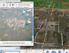 Now that Google Earth is available for Mac, I've been having some fun. This screenshot is one result.